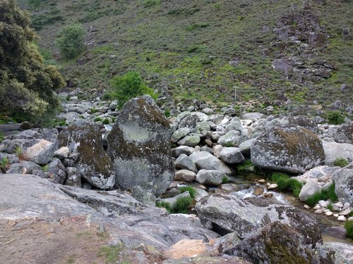
Garganta de los Infiernos, Extremadura, Spain
4.5 (607 reviews) Thursday: 10:00 AM - 8:00 PM Spent Ranking #2 in Extremadura Geologic Formations
An amazing place
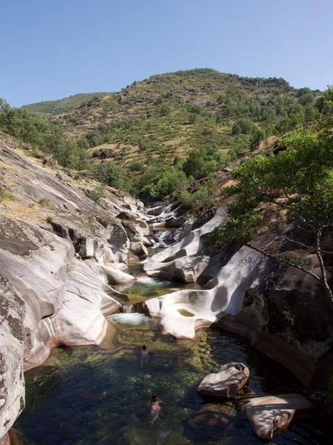
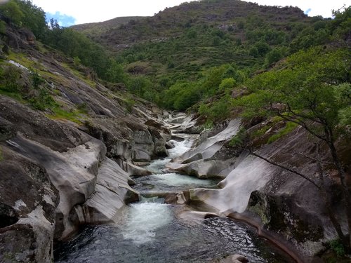
Hiked up here in the summer months, it took about 45 minutes to get to the pools (Los Pilones). We went up at about 16h stayed until about 21h and it was just magical. The waters warm and crystal clear and the landscape stunning. Spring time is next, as we want to see the cherry blossom.
Address
Reserva Natural Garganta de Los Infiernos. Jerte Municipio de Jerte, Caceres, 10612 Jerte Spain
Mobile
Website
http://www.facebook.com/ReservaNaturalGargantaDeLosInfiernos
Working hours
Monday : 10:00 AM - 8:00 PM
Tuesday : 10:00 AM - 8:00 PM
Wednesday : 10:00 AM - 8:00 PM
Thursday : 10:00 AM - 8:00 PM
Friday : 10:00 AM - 8:00 PM
Saturday : 10:00 AM - 8:00 PM
Sunday : 10:00 AM - 8:00 PM
Current local date and time now
Thursday, May 16, 2024, 3:55
User Ratings
4.5 based on (607 reviews)
Reviews
-
5no_place_unlike_home 5:00 PM Jun 11, 2017
Wonderful outing - read more for details about access and the trail
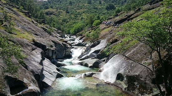
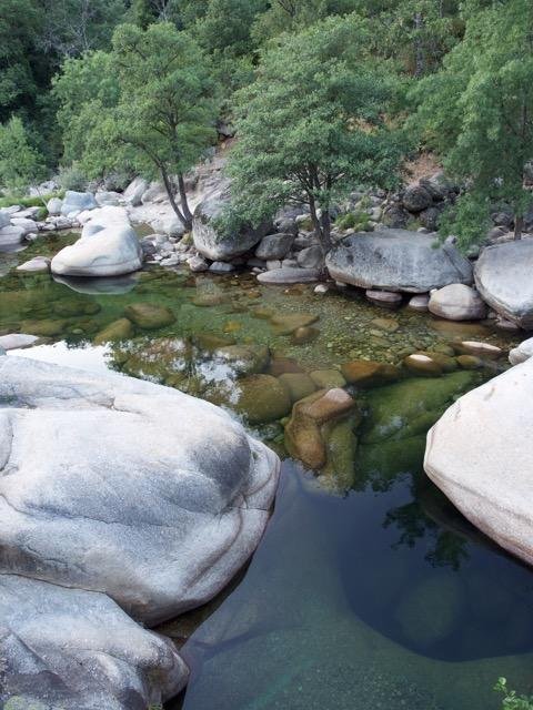
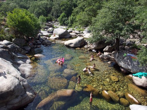
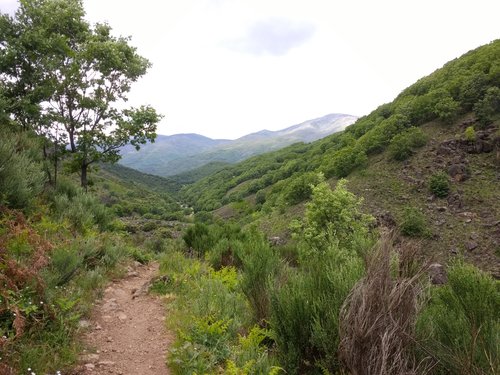
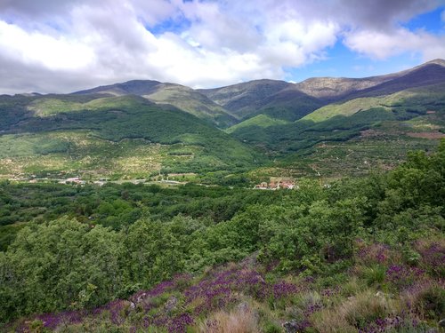
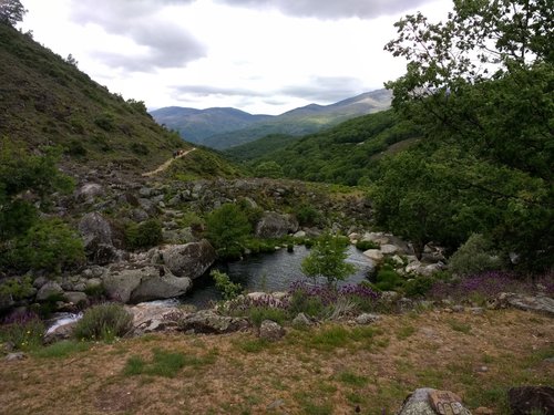
We were advised by some acquaintances to cool off on a hot day at Los Pilones, a series of natural swimming pools, at the Garganta de los Infiernos. The trailhead is easily reached from the main highway that passes through the Jerte Valley. You drive through a campground (watch out for the short single lane bridges) to a Nature Center (Centro de Interpretaciónes) where the trailhead is located. Parking is limited but there is overflow parking on the road leading to and from the center. There is also a small inexpensive restaurant on site for sit-down meals or sandwiches and cold drinks to go. It's a three kilometer walk to the pools on a well-marked trail. Depending on the weather and your fitness level, it's a 45-60 minute walk that is not technically difficult. It is a steady uphill climb with about 100 meters' gain in elevation. It was a very hot day and we were relieved to discover that most of the trail had shade (small oaks predominating) and there were only a few small exposed stretches. The trail was very pretty, offering occasional views of the surrounding mountains and terraced farms. The last several hundred meters is an old cobblestone road. Once there, you will be rewarded by several interconnected pools of refreshingly chilly and very clear water. Many families and groups of young people were picnicking and relaxing. They were very mellow and conscientious about packing their trash out and picking up random bits left by others. The surrounding area is a fruit growing region, specializing in cherries. It is beautiful in its own right and the cherries are sublime!
-
4Danny M 5:00 PM Jul 18, 2018
Nice walk till there... and beyond
We walked to the Garganta de los Infiernos on an average day early may, but even then it was rather crowdy already. Be sure to have good walking shoes, the terrain isn't always smooth : the few rough cobblestone parts can be more difficult for stepping than the trails in the woods (nevertheless we've seen several persons with slippers - looked crazy). You can choose to stop at the waterfalls of the river (called Los Pilones) - like most people seem to do, or continue further. Not that much people seem to continue beyond the waterfalls - but you get some really beautiful views along the road. After the cascades of Los Pilones the track follows the river on a higher altitude for a while - and instead of crossing the river by the bridge near the ruins of the mill we decided to continue following the trail. A short time later we had to cross a small river full of rock which was along our path, full of big rocks - so my wife needed some help to cross - but it was possible. Actually - after that river there isn't much path left - so probably we should have crossed the river further upstream where a bridge should link to a trail. A next occasion to cross the river for returning is a very ancient bridge at the 'Carlos V' point a few km further (joining again the trail coming from the other bridge upstream of the other river) From that point the trail starts climbing again. Near the top it changes into a concrete road to descend (rather steep) to the starting point - which is the less enjoyable part of the hike.
See also
More Things to do in Extremadura
- Points of Interest & Landmarks in Extremadura
- Architectural Buildings in Extremadura
- Churches & Cathedrals in Extremadura
- Historic Sites in Extremadura
- Ancient Ruins in Extremadura
- Art Museums in Extremadura
- Speciality Museums in Extremadura
- History Museums in Extremadura
- Castles in Extremadura
- Bridges in Extremadura
- Historic Walking Areas in Extremadura
- Waterfalls in Extremadura
- Nature & Wildlife Areas in Extremadura
- Neighborhoods in Extremadura
- Geologic Formations in Extremadura
- National Parks in Extremadura
- Farms in Extremadura
- Caverns & Caves in Extremadura
- Mines in Extremadura