Dog Mountain Trail, Washington, United States
4.5 (32 reviews) Spent Ranking #1 in Bingen Hiking Trails
Great trail for dogs off leash
An absolute marvel of a location. It’s encouraged to have dogs off leash, and with 150 acres, the dogs had a blast. A lot of the messages scattered throughout the property were absolutely heartwarming. There were a lot of individuals who came by just to wish their dogs who crossed the rainbow bridge well.
Address
Washington State Highway 14, Milepost 53, Bingen, Washington, United States.
Website
http://www.wta.org/go-hiking/hikes/dog-mountain
Current local date and time now
Sunday, May 12, 2024, 12:08
User Ratings
4.5 based on (32 reviews)
Excellent
72%
Good
16%
Satisfactory
6%
Poor
3%
Terrible
3%
Reviews
-
5Paul M 5:00 PM May 31, 2018
Strenuous hike with breathtaking views
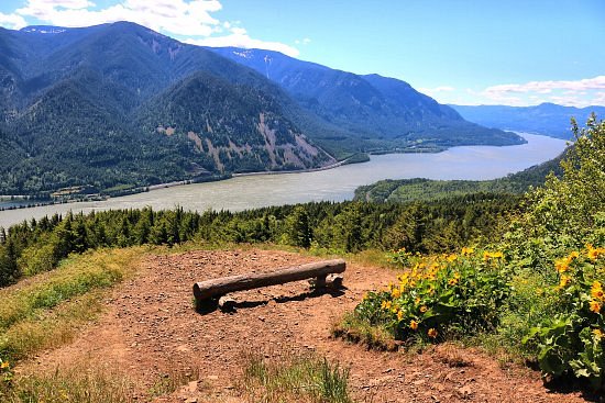
This is one of the few hikes that are still open after the fire of 2017. It's a steep, constant uphill with almost 3000ft of elevation gain in about 3 miles. Your reward though, are some stunning panoramic views. There is a parking lot that can take I'd guess up to maybe 40 or 50 cars. DO NOT park anywhere except designated spaces or you will be towed. This happened to several people whilst we visited and we ended up having to give a couple a ride to the impound lot. There's a $5 fee payable at the trailhead for parking, or you can use a Forest Pass or Interagency Pass, just be sure to leave them on display in your car. From March 31 to July 1, if you want to hike on a weekend you'll need a permit. I believe there is also a shuttle bus available to and from the trailhead that leaves from the Skamania County Fairgrounds parking lot. Fee is $1 each way and if you ride the shuttle you will get a free hiking permit. The trail itself is about 6 miles roundtrip, but please be aware that this is a very steep trail. We met so many people on our way down that were really struggling and weren't anywhere near the top. After a short steep climb you'll come to a fork in the trail where a sign points right to 'difficult' or left to 'more difficult'. There's not much difference in distance but the sign is certainly correct. The left fork is very steep and has few switchbacks, just a constant uphill slog to the top. The right fork is a little easier and has a nice lookout point part way up. I'd advise anyone unsure of their abilities to take the right trail and try to make it to that viewpoint, then see how you feel from there. We took the left trail up (from the parking lot to the top via this route took us about 1h 30m, including stops for photos and rests) and came back down the other, which seemed not quite as steep and it had a few steps and switchbacks. Watch your footing as the trail was dusty and full of loose stones and pebbles when we went, hiking poles will certainly help up and down. When you finally emerge above the treeline, the meadow area is quite exposed so be sure to pack the correct clothing for the weather and a windbreaker is a good idea. We visited late May when the awesome display of wildflowers was still in full force, though the views from the summit are truly amazing any time of the year. We were lucky to have a clear sunny day and enjoyed far-reaching panoramic views of the Gorge and surrounding landscapes. Someone else has put that dogs are not allowed on the trail, but we saw plenty of people with their dogs whilst we were hiking and the shuttle is dog friendly so I'm pretty sure they are allowed, after all, it's called Dog Mountain.
-
4Travelnat 5:00 PM Feb 26, 2021
It’s a hike
Did this hike in February. Decent amount of parking along the highway, and there is a toilet at the trailhead. It’s many many steep switchbacks. The view at the top was quite nice, sweeping views of the Columbia and the hills across the river. But there always also a lot of wind and it was cold.