Chain Lakes Loop, Washington, United States
5.0 (37 reviews) Spent Ranking #18 in Bellingham Hiking Trails
Great for noobs!
Easy access. I’ve been here in the winter spring and summer. All 3 times were fantastic. I’m not an expert hiker and I had an excellent time. Such stunning views. If you have the right boots or sandals (for me anything with Vibram technology) you will be able go far on this trail. It was iced over in December so we needed spike traction cleats for our shoes. If you are new to hiking this is an excellent place to start.
Address
This attraction should be listed under Glacier, WA not Bellingham, WA, Bellingham, Washington, United States.
Website
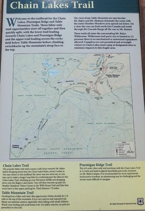
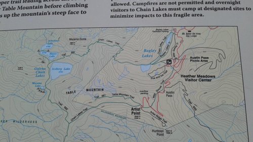
http://www.wta.org/go-hiking/hikes/chain-lakes-3
Current local date and time now
Sunday, May 12, 2024, 18:06
User Ratings
5.0 based on (37 reviews)
Excellent
97%
Good
3%
Satisfactory
0%
Poor
0%
Terrible
0%
Reviews
-
5Bottomshelfhockey 5:00 PM Aug 10, 2015
Trail System – 3 out of 5 rating; Vistas up top - 5 out of 5 rating
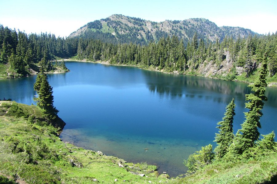
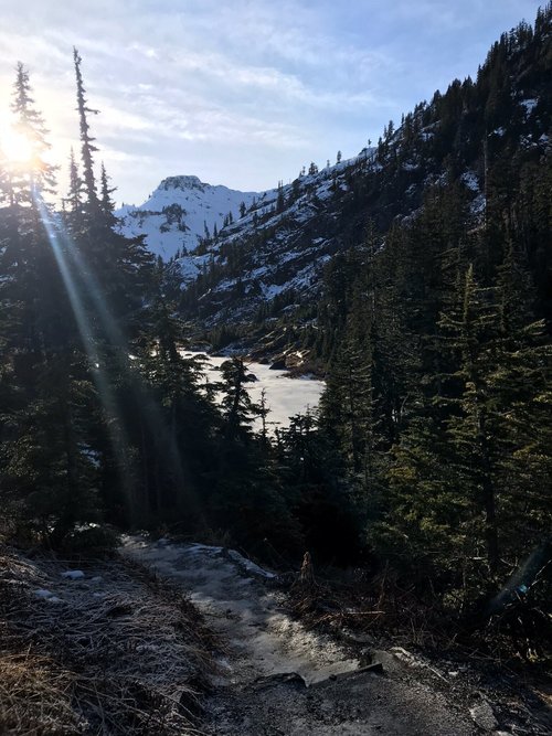
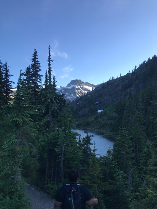
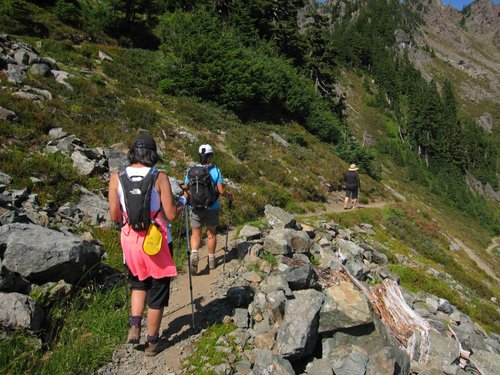
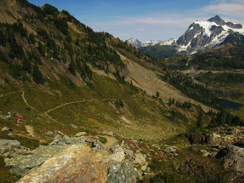
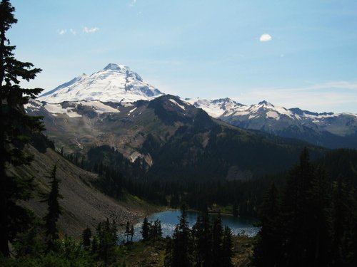
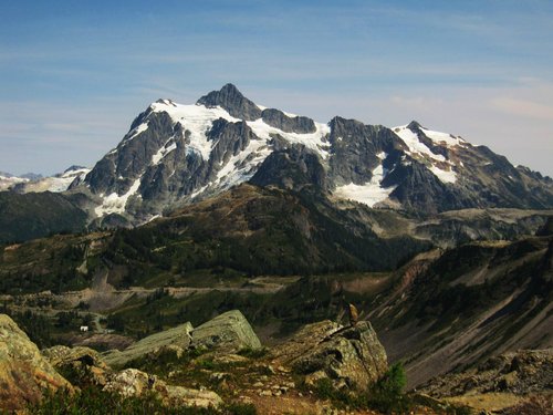
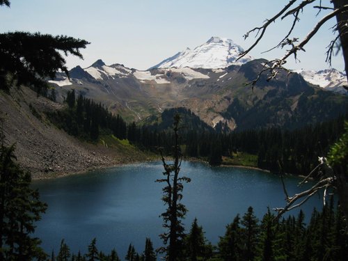
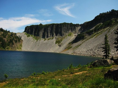
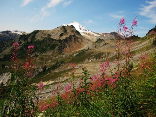
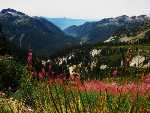
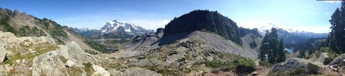
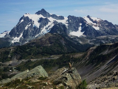
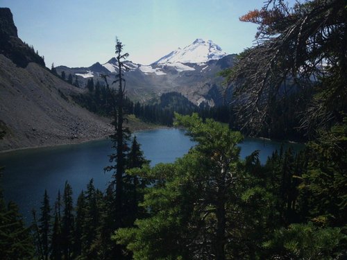
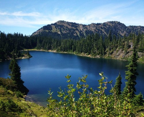
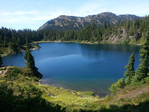
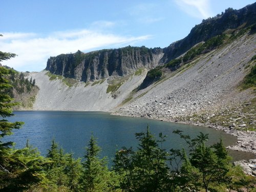
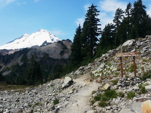
Our group of 7 did this hike on the first August Monday. If you are contemplating about doing thing hike, perhaps a little background on our physical abilities will give you a better idea. Of the seven hikers, 6 of us belong to the same fitness club and or are runners with the 7th member involved in aquasize classes. The first 5 are in relatively good shape in terms of endurance with 6th person who also does dragon boat paddling has exercise induced asthma. Regardless, we all finished the hike, some a little more sore than others. I would say except for 2 in the group, the rest of had very little hiking experience (mostly short easy hikes). I fall in into the latter category – novice hiker. Age-wise our group averaged 60. On our hike we didn’t see many baby boomers, if any at all, doing the hike. There were a lot of younger people on the hike and even dogs with their masters. In my opinion, if you can walk 3 – 6 miles, it is not a hard hike relatively speaking. Even for the walking challenged, if you take a lot of water breaks and photo op stops the hike can be done over a longer time span. That is not to say there aren’t some difficulties. Let me make it perfectly clear, your physical conditioning will make a great difference in how you feel during and after the hike. We purchased our parking pass ($5) at the base of the mountain before heading up to Artist Point parking lot. The rationale for parking here was that if we parked at a lower parking lot the hike begins immediately uphill as opposed to a gentle ascent. At the Artist Point parking lot, we took the Chain Lakes trail to begin the clockwise hike. Through out this trail system there is nothing too steep as it winds it way up and towards the ridge. One of the problems is that the rocks come in all sizes pebbles, golf/tennis ball sized etc.; so you need to be careful with your foot placement. I’m speaking from personal experience as I fell on my butt when I slipped going downhill and ended up with a bruised ego and a slight rash! Since we went during the first week in August, the trail conditions were dry. The rewards once you get to the ridge (Herman Saddle?) are the magnificent vistas of Mt Shuksan and the surrounding area. If you get to this point, here are the 2 options that I know of (there maybe more): • Go back the same way • Complete the loop Once at the top, if you decide to complete the loop, it is a gentle downhill all the way on a series of switchbacks on 4-5 feet wide paths. The paths here, in general, consist of dirt and gravel/pebbles. A section of the trail before Upper Bagley Lake (if you’re hiking in a clock-wise direction) is composed of large stone rocks; but not large enough to be stable if you stepped on them. Another section above Upper Bagley Lake has this 30 – 45 foot section that may cause some anxiety - scary to some. The troublesome section looks onto Upper Bagley Lake, about ¼ mile before the rock bridge that crosses over the lake to the other bank. This section is a walk across the rock face ledge (in my opinion, narrow but manageable ledge) with the lake below (20-30 feet below?). The 3 men in the group traversed this section of the rock trail without any difficulty. Two women had slight difficulty and hesitancy in crossing (probably due to anxiety/fear of heights and the narrowness of some portions of the ledge) and the other 2 women had to be assisted. Upon further reflection, quite possibly, there may have been an easier route to bypass this section that we may have missed. I sent an email to forest services regarding this section and the ranger told me there was no alternate route to bypass this section. I would ask the park ranger or another hiker before you consider going this route if you have any concerns. The second potential issue once you past the “troublesome” section is more of a physical endurance issue and depends on your choice of following the Lower Bagley Lake trail to the left after crossing the rock bridge or going straight ahead after crossing the rock bridge. If you decide to go straight ahead after crossing the bridge, it is an uphill climb that eventually leads you back to Artist Point via the Wild Goose Trail. One website says the elevation gain is 1200 feet in the final mile to Artist Point. I stayed back with the 3 slower hikers and followed the Bagley Lake Trail to its end at the Bagley Lake trailhead parking – mostly flat, where we were picked up. The faster hikers took the steeper route to get the Artist Point parking lot. It took us about 6 – 6 1/2 hours to hike the loop trail (7+ miles). The hike can be done in less than time. We took a lunch break by one of the lakes and numerous water breaks, to admire the scenery and take photos. Would I do it again? The answer is “yes” now that I know what to expect. In terms of difficulty of the hike I would rate it at 3 out of 10. The only difficulties, if any, your physical conditioning as there is a lot of walking involved sometimes across uneven and rocky terrain and that one section crossing a rocky ledge. The views up top are very impressive thus the 5 out of 5 rating. I gave the trail system a rating of 3 out of 5 because of the way Mother Nature and man has constructed it; specifically the all-rock trails can be treacherous if you’re not careful. Notes &Tips: • If you’re going clock-wise and you don’t want to hike to the top of the ridge, hike to the first lake and turn back. The downside is you don’t see all the scenery but you also avoid that “scary” rocky section at the Upper Bagley Lake. • I don’t know how true it is, but I was told Mt. Shuksan was the most photographed peaks in Washington State, if not the world. • Short hiking season • Bring swimming suits and towels if you plan to take a dip in the lake. • There are no “real” toilet facilities on the hike. I only remember seeing 1 toilet signpost on the first half of the Chain Lakes trail. One of the hikers used it and it is apparently it is a hole in the ground with a cover. There are washroom facilities at the Artist Point parking lot – non-flushing toilets. • Where you park depends upon your final destination. We parked at Artist Point with the plan that some of the group would hike the extra kilometre or so back to get the car albeit in an uphill direction. To avoid the uphill at the end, start counter-clockwise from Artist Point parking lot to the Bagley Lakes trailhead via the Wild Goose trail. Another option, you can start the hike at the Bagley Lakes parking lot and then complete the hike via the Wild Goose trail back to the Bagley Lakes parking lot. • Check national parks website and other websites for additional information and tips • I believe you can buy a parking pass at the Heather Meadows Visitors Center, if you miss buying your vehicle pass at the base of the mountain. Check before you go! • There are free ranger-led programs at Heather Meadows with guest speakers and will be offered during the 2015 summer and fall. Google Heather Meadows Visitors Center for additional details. For all the novice hikers, here are some things to consider and take with you: • Trail map • First aid kit, • Even brought imodium; good thing we did as 1 hiker had stomach issues • Lots of waters - minimum 2 litres (64 ounces/2 quarts). Four of us had backpacks with water bladders. • Bring hat, suntan lotion as there is little or no shade • Small wet face towel in Ziploc bag; nice and refreshing when you need it • Bring toilet paper • Good runners or hiking boots • Bring a bag lunch and high energy snacks. No cafeteria facilities • Some bugs, bring bug spray • Hiking poles should be a consideration; probably recommended For comparative purposes and for those that have done the Sea to Summit hike in Squamish, the Chain Lakes trail is by far the easier hike. The Squamish trail is a point-to-point (bottom to top) hike about 7.5 kilometres (4 1/2 miles) in length (longer if you add the Shannon Basin Loop) and definitely harder than the Chain Lakes trail. In addition, the Chain Lakes trail is open meadow hiking with gentle inclines whereas the Squamish hike is through an old growth forest on a “carpeted” trail. There are undulating sections – gentle declines and inclines and at two points (or 3 points depending on route) require you to use rope and chain assistance to climb up. The sections that require assistance are short inclines not more than 20 yards in length. Other sections require you to climb up man-made trails. The Sea to Summit trail has the more varied terrain but no all-rock sections of trail like the section just before the Bagley Lakes. As for elevation gain, Sea to Summit wins hands down, 2900 feet versus 1700 feet. However, the Chain Lakes altitude is 5400 feet versus starting at around sea level (about 115 feet) and rising to 3000 plus feet at the top of the Squamish Lodge. The views are throughout on the Chain Lakes trail as you are hiking in alpine meadows versus hiking through old growth forest on the Sea to Summit trail with the reward of magnificent views at the top. One advantage of the Sea to Summit is that you can sit down and have a beer at the lodge up top! See my 2 reviews of the Sea to Summit trail hike.
-
5J5029JApeterb 5:00 PM Jul 12, 2015
Mt. Baker Chain Lake Loop
A 4 to five hour loop with fascinating alpine views of snow covered mountains and pristine lakes. The entire loop does require some steep up hill hiking, however it is worth the efforts. Having hiked in many places around the world, this is definitively one of my favorite ones. You will not regret it. If you are not into too much up hill hiking, start from Artist Point and return after 2 hours the same way you came. Its absolutely fabulous. There are several overnight camp grounds available on the first half of the loop from Artist Point, Mt. Baker