Mount Sugarloaf State Reservation, Massachusetts, United States
4.5 (89 reviews) Spent Ranking #3 in South Deerfield Nature & Wildlife Areas
Great place to hike with young kids
Excellent hike on a rainy day. Parked at the south entrance and hiked to observation tower with my 5 year old. It is steep from the lot to the observation area, but not overly challenging. Best route for kids that are sure footed hikers. I would probably not bring my clumsy 12 year old this way. Hiked back down the back way which is much more of a gentler slope, just a longer hike. Had a blast. Views would have been great had it not been raining. Had a great time anyway.
Address
300 Sugarloaf Street, South Deerfield, MA 01373
Mobile
Website
http://www.mass.gov/eea/agencies/dcr/massparks/region-west/mount-sugarloaf-state-reservation.html
Current local date and time now
Wednesday, May 15, 2024, 11:35
User Ratings
4.5 based on (89 reviews)
Reviews
-
5Maurene_K 5:00 PM Sep 18, 2016
SPECTACULAR VIEWS FROM THE SUMMIT & OBSERVATION TOWER
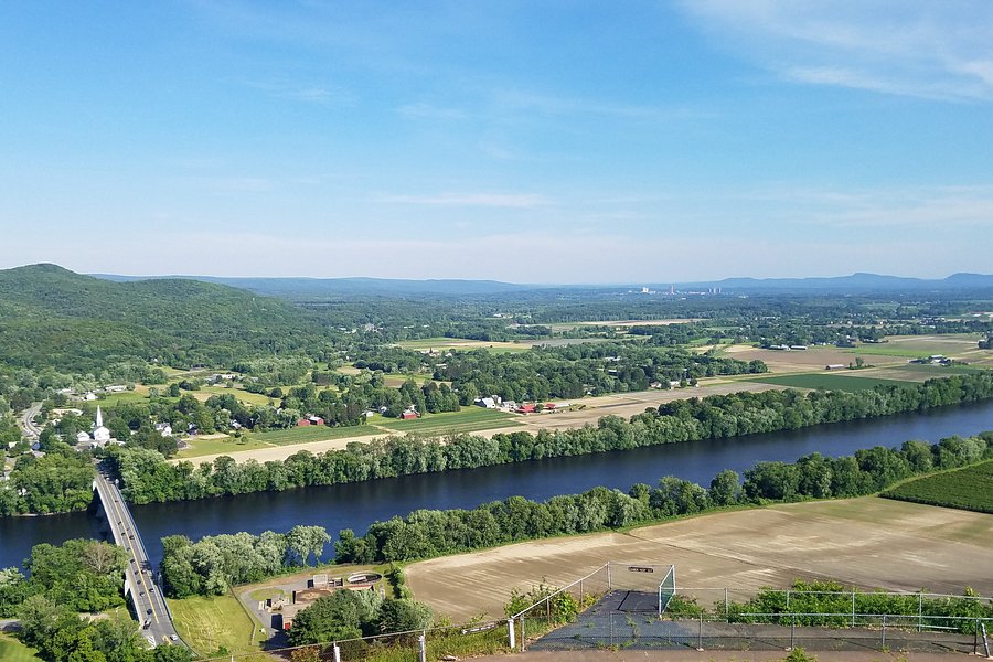
Mount Sugarloaf State Reservation is easy to get to. The entrance is just off MA State Route 116. There is a very small lot with free parking for hikers near the entrance to the auto road . For those driving to the summit, there are parking fees: $5.00 – In-state cars $6.00 – Out-of-state cars The pay station is an automated attendant that takes cash or credit. Mount Sugarloaf is a butte mountain with two peaks. North Sugarloaf is accessible only on foot. Its elevation is 791 feet. South Sugarloaf Is accessible by foot and by the auto road. Its elevation is 652 feet. The southern terminus of the Pocumtuck Ridge Trail is right near the pay station and ascends South Sugarloaf and then goes northward to Rocky Mountain in Greenfield, MA. The portion on South Sugarloaf Trail is about 1.4 miles long. After the first 100 feet or so, the trail begins the ascent and zigzags its way up the mountain. Although rated moderately difficult, it can get steep because this mountain is classified as a butte. The trail can also get rocky. The mountain is mostly sandstone. Many folks elect to trek up the auto road instead of taking the trail. Whichever way one chooses to go, the views from the summits are stunning. My visit was to the South Sugarloaf summit. Near the parking lots was a picnic pavilion with a grill, plus some open tables out in the sun. I had a mid-morning snack there. Mount Sugarloaf offers commanding views of the Connecticut River and the Pioneer Valley, plus the Pelham Hills and Berkshire Hills. The most striking thing in the landscape is the Connecticut River as it winds its way through the valley. Next are the picturesque towns and the various types of farms that form a checkerboard pattern in some places. I also climbed the Observation Tower. There were two levels with viewing platforms. There are about a dozen steps up to each of two steep, narrow spiral staircases. The views are worth the climbs. I recommend descending these stairscases backwards. On the day of my visit, humidity was very low so the views had very little obstruction by haze. I could see for many miles in each direction. Back down on the ground, I found paved viewing areas with standing binoculars. During my time up in the tower, a man had arrived and was busy with his crossword puzzle at one of the tables in the sun. He’d also packed a lunch or snack in his insulated bag. The Mel Gibson film “Edge of Darkness” was filmed at the summit of South Sugarloaf. Mount Sugarloaf State Reservation is a beautiful, scenic place. I plan to return during foliage season in 2017. I highly recommend a visit. If you found this review helpful, please click THANK below.
-
5babynbaby 5:00 PM Oct 21, 2020
best view
This place has an aswome view from the top and a great place to take pictures from. I was really shocked to have real bathrooms. The only down fall is $20.00 to park,I thought that was a rip off.